The History of the Landmark “Folly Boat”

2024-02-14T15:25:22-05:00

The History of the Landmark “Folly Boat”

Have you ever encountered a boat with lots of graffiti on Folly Road? How did it get here?

For years, visitors and residents pondered the origins of “the Folly Boat” positioned just before the bridge leading to the island. The “Folly Boat” arrived on Folly Road after Hurricane Hugo in 1989. Initially pushed ashore by the storm surge near the bridge, its owner kept it unclaimed for nearly three decades. In the aftermath of Hurricane Hugo, locals, and visitors turned the Boat into a canvas for messages and art, serving as a platform for birthday wishes, marriage proposals, and any other messages people wanted to share with the world. However, though temporary, these messages encountered challenges, with some painted over daily.

In 2017, Hurricane Irma altered the landscape, displacing the landmark from its roadside location and depositing the “Folly Boat” onto the dock of resident Chris John. Chris John, eager to restore the famous “Folly Boat” to its original roadside spot, faced hurdles as the city declined permission, citing regulations and laws. Instead, the town favored relocating the Boat to private property.

Over time, layers of paint accumulated, causing chunks of the Boat to break and peel off. Nevertheless, the vessel persisted as a literal embodiment of free speech, with people continuing to paint messages and art on its sides. Unfortunately, the city’s refusal prompted owner Chad Reynolds of The Barrel, a James Island Bar, to take matters into his own hands in December 2019. He moved the Boat to the edge of The Barrel’s property, extending beyond the south side fence. The Boat, cautiously lodged in the mud behind Chris John’s house, faced the possibility of being sent to the junkyard. Now on private property, the tradition lives on, with individuals still visiting to paint the Boat with ambitious messages and art, preserving the enduring legacy of this Folly icon.

After 23 years, the Folly Boat is still a big hit. It got featured on the cover of “The Humours of Folly” by Ellie Maas Davis and Frank Braden. FollyBoat.com has excellent photo galleries showing how it’s been painted since 1993, and you can even send in your pics. They’re planning to keep adding more. But, more than just being online, the Folly Boat is a local favorite, like a symbol of the place.

Folly Beach…The Edge of America

2019-11-07T15:38:15-05:00

Folly Beach…The Edge of America

From its laidback energy, friendly community, expansive beaches and event-filled calendar, Folly Beach, South Carolina has a unique sense of character that offers something for every visitor. It has been known as “The Edge of America” for so long, that most people don’t remember exactly how it picked up the nick-name, but it is likely a combination of geography and state-of-mind:
It is on the edge – literally. Folly Beach runs down the edge of coastal South Carolina and is a dead end found at the tip of the Charleston Peninsula. The six-mile-wide beach attracts surfers and other fans of beach activities such as sailing, kayaking, fishing and biking. This beach on the “edge” also offers myriad restaurants, bars and shops.

The Edwin S. Taylor Folly Beach Fishing Pier is one of the longest piers on the east coast, stretching out more than 1,045 feet into the ocean. This allows visitors to further take advantage of being on the “Edge of America” and offers a spectacular view from the outside looking in.

The vibe is chill. Another theory behind the “Edge of America” nickname is the laid back lifestyle. Residents and visitors of Folly Beach are said to truly “live life on the edge.” While Folly Beach is only a short car ride away from the busy and popular downtown Charleston it is about as far away as you can get from city living. From casually spending their days relaxing on the beach or shopping around town to surfing some of the best waves in South Carolina at the Washout, the way of life in this beach town is definitely carefree. There countless opportunities to have fun with friends and family throughout the year, at events like Dancing-Moonlight Mixers, Sea and Sand Festival, Folly Gras, the Flip Flop Drop and more.

Folly Beach is a special destination with an abundance of history, activities and a remarkable personality. Next time you enter the city, you will have a better understanding and appreciation of the greeting sign that says, “Welcome to Folly Beach, the Edge of America.”

Sources:
https://www.charlestoncitypaper.com/charleston/the-eroding-edge-of-america/Content?oid=4646754

https://www.ccprc.com/1753/Folly-Beach-Pier

Come Visit the Historic Seashore Farmers’ Lodge

2019-11-07T16:00:34-05:00

Come Visit the Historic Seashore Farmers’ Lodge

The Seashore Farmers’ Lodge, located in the Sol Legare community on James Island has recently been restored as a cultural museum that is also open to the public. Built in 1915, The Lodge was established for a fraternal organization and mutual aid society known as the Sol Legare Seashore Farmers’ Lodge No. 767. Its importance to the Lowcountry African American community was compelling, as it provided health and life insurance to it’s members. Organizations like these were very popular in the early 20th century and provided a close community and support system for its members.

Over the past few decades, The Lodge became increasingly unstable and was deemed unusable after Hurricane Hugo in 1989. Since then, restoration efforts have tried to help restore The Lodge but it wasn’t until it was featured on the reality show Flip This House that it was finally able to reopen as a cultural museum.

A trip to The Seashore Farmers’ Lodge will provide a captivating look into the decades of community ties that were built in the Sol Legare community during the early 20th century as it its walls truly encompass the heart and soul of the South.

Source: https://www.sciway.net/sc-photos/charleston-county/seashore-farmers-lodge.html

Historic Mosquito Beach

2019-11-07T16:00:21-05:00

Historic Mosquito Beach

Mosquito Beach is a historic beach located in the Sol Legare community of James Island. In the peak of segregation in the 1950’s, African-Americans weren’t allowed to enjoy the local beaches such as Folly Beach, which meant they had to travel further to enjoy the waterfront. Mosquito Beach, which got its name from the insects that populate the area, became the local beach for African-Americans in the ’50s.

It soon became a popular area with businesses, restaurants and dance halls opening up all along the strip. Even after desegregation, it was still an area of interest for many until it became invaded with violence. Two murders occurred within three years in the 1950’s and after that, the violence only continued. For decades, the community has been taking steps to eliminate the violence in order to maintain the historical significance of the area. The landowners have also agreed to preserve the history and culture by not allowing property owners and outside businesses to take over. They hope to create a peaceful and relaxing environment like it was in its prime and continue to reminisce on its important history that collectively makes Charleston so significant.

Source: https://www.sciway.net/sc-photos/charleston-county/mosquito-beach.html

McLeod Plantation to Begin Cultivation of the Once Extinct Sea Island Cotton

2019-11-07T16:01:57-05:00

McLeod Plantation to Begin Cultivation of the Once Extinct Sea Island Cotton

The historic McLeod Plantation has started a cultivation project with Sea Island Cotton (Gossypium barbadense), a species of cotton that played a major role in the advancement and enrichment of Charleston’s early economy and history. Although thought to be extinct in South Carolina in regard to modern day agriculture, Sea Island Cotton has a long history of growing on the plantation until it was destroyed in the 1920s by the Boll Weevil, a beetle that fed on the plant and drove it to extinction.
 
On May 22, 2017, the newly acquired Sea Island Cotton seed was planted on a quarter of an acre in the plantation’s former cotton fields. “Sea Island cotton, along with rice, had a very important influence on the development of the Lowcountry and Charleston,” said Bill McLean, a local attorney and James Island resident . “Locally produced Sea Island cotton was the finest and most valuable cotton fiber ever produced anywhere and provided the desired genetic traits of the finest cottons grown in the world today. It has taken on legendary status.” This agricultural addition to the McLeod Plantation will contribute to its great historic importance. 
 
The reintroduction of the Sea Island Cotton is an exciting initiative however, it is important to recognize that it’s early cultivation was done though generations of slave labor and oppression. Shawn Halifax, the McLeod site historian and cultural history interpretation coordinator for the Charleston County Parks and Recreation Commission comments that “… this calls for solemn remembrance, too”. The Sea Island Cotton planting project hopes to add historic significance to the James Island plantation and offer visitors a glimpse of Charleston’s intricate history. 
 

The Construction and Destruction of the Swamp Angel

2017-08-20T17:34:25-05:00

The Construction and Destruction of the Swamp Angel

Blog By Paul Hedden

By the middle of July, 1863 Union troops, under the command of Maj. Gen’l Quincy Gilmore, had consolidated their position on Folly Island, with a foot hold on Morris Island, and the troops made further attempts at establishing a more secure position on lower James Island by a feint aimed at Grimball’s landing via Battery Island. The overall strategic plan, however, remained: capturing Folly and all of Morris Island to enable a direct land based assault on Fort Sumter, and ultimately Charleston, itself.

To move this strategy forward, on the 15th of July orders were issued to determine a position in the marsh between Folly, Morris and James Island where a gun battery could be placed that would enable Union forces to bombard Charleston itself.

The following day orders were received by Colonel Edward W. Serrell of the New York Volunteer Engineer and his subordinate Lieut. N. M. Edwards to locate a site for the battery. The mission took them across the marsh from the batteries on Folly to the creek between Morris Island and Light-House Creek a distance of about half a mile. At this point there was a spot of hard ground just above, or below, high-water depending on the tide. This bit of occasionally dry land, from 25 to 80 feet long. and 15 to 18 feet wide,was almost at 90º to the enemy fire from Fort Sumter. This area of the marsh could only be be crossed by infantry at low tide, and with some difficulty. A man crossing on foot could possibly sink 2 to 8 inches if not more. A battery to be constructed at this point had to be entirely made of sand-bags, with platforms placed on a grillage (a framework of timber or steel for support on marshy or insecure ground).

The proposed surface for the gun, or guns, weighing no more than 10,000 pounds, would be drawn across the marsh on skids to slide over the mud. At this location it was estimated two thousand three hundred men would be needed to carry enough filled sand-bags, in one night, to make the battery and cover the magazine. Sixty more were estimated necessary to sled the platform across and put it in place on the grillage. Another 400 to 450 men would have to put the guns in position the next night. The required skid would require a surface, on the mud, of 90 to 100 square feet. Another 35 men would have to haul the magazine across this muddy and treacherous path and set it up. Or approximately 4800 men total. The possible placement of the battery at this site came with two additional difficulties: a small creek, about 9 feet wide was in the way, with only a narrow ‘bridge’ of three logs to cross over, and the work had to be completed in daylight, in sight of enemy guns.

Subsequent examinations of various sites were sought down stream between Light-House Creek and Vincent’s Creek; on the morning of the 30th soundings were made with an iron rod 30 feet long, and ¾ inch in diameter at a site located midway between Morris and James Islands, 7,000 yards from the lower end of Charleston City. The chosen location was named the Marsh Battery, although it is generally known as the Swamp Angel, a name conferred upon it by the soldiers.

In these marshes, back from the harder edges of the creeks, the mud is generally about 20 feet deep. It is so soft that the weight of the sounding iron will carry it down 8 or 10 feet, and a man can push it the remainder of the distance to the bottom which has the feel of hard sand. At the selected location the surface of the mud, though covered by a growth of very coarse grass 4 or 5 feet high, didn’t provide secure footing, nor substantial resistance to anything sinking through it; at high tide water covered the surface of the mud. The edges of the small creeks bisecting the marsh are hard, and frequently filled with oysters and oyster shells; yet a few feet from the water the marsh again becomes very soft, again not affording a stable foothold. The gelatinous qualities of the marsh can be demonstrated by the fact two men on a plank resting on the surface can shake the surrounding surface of the marsh by bouncing themselves about. The vibrations extend over many hundreds of square yards, as if they were on jelly.

Knowing this the construction engineers formed a general idea of the kind of structure to be built and made preparations to obtain the necessary material, and provide the means of getting it placed as near to the city of Charleston as practicable on a stream just southeasterly from Light-House Creek. During the time preceding the final approval of this site and the commencement of the work at this location, a causeway leading to Black Island was being built. This demanded the use of large timber in great quantities. Working parties were sent to Folly Island to cut and prepare the lumber and bring it forward ready for use. It was determined that the proposed parapet must be made of sandbags. A point was chosen near the engineers camp: troops, and working parties worked day and night filling bags and hiding them from the enemy’s view under the over of bushes and ridges. The platform used as a base for the parapet was loaded with sand-bags, piled in regular layers, until a load equal to 400 pounds/sq ft was reached; and although the mud was so soft that the sandbags could not be carried by the men without sinking, except by walking on boards, the column of bags on the platform remained standing, and, after twenty-four hours, showed no signs of settlement.

Then more sand-bags were piled upon the column, reaching a height of 7 feet, with a weight of about 650 pounds to the square foot. This resulted in a tilt to one side. This was thought to be caused by the soldiers “tramping about near the corner that went down first.”

After a return to a state of equilibrium additional bags were piled upon the column, until a force of about 900 pounds/sq ft on the platform was reached. The platform suddenly tipped, throwing sand-bags into the marsh., burying many on the top tier into the mud. The platform sank only about a foot at one corner. This trial showed the sustaining strength of the marsh was equivalent to over 600 pounds to the square foot when the load was uniformly distributed. The ultimate sustaining strength was not ascertained.

Now, the average weight of a Union soldier was calculated to be 143¼ pounds [see The Men In The Union and Confederate Armies, at http://civilwarhome.com/themen.html]. And a man weighing150 pounds presented something like a force of 500 or 550 pounds/sq ft. when walking. So if a battery was to be built, so long as the guns were not fired, the forces would essentially be static. But guns, to be offensively useful, must be fired, and to fire them while floating, as it were, on the surface of the mud would produce vibrations. How far these vibrations would affect the stability of any structure so situated was still undetermined.

This conundrum indicated a free-floating battery would not be able to sustain a long-term bombardment of Charleston; a battery anchored to the floor of the marsh was necessary. If a pile-driver was to be employed to make a foundation, provision would have to be made to hide it during the day and work it at night, or it would be destroyed by the enemy’s fire. A machine as large as a pile-driver could not be used. The time required to set it up and take it down during the short nights of summer would consume too much of the few hours there were left to work in with any degree of security. For this reason a device was improvised where, a number of men forced the piles into the mud until the point reached hard bottom. It was then driven into the sand securely by heavy wooden mauls.

On the morning of August 2nd, General Gilmore had approved the plan for construction of the battery. Simply, the general theory of the structure is this: The marsh, being capable of sustaining a given weight, and no more, to the square foot, and it being necessary to have a certain height and thickness of parapet, thought best to be made of sand-bags, an equation was worked out to determine the size of the foundation and the weight to be supported. The foundation had to be large enough to support the necessary weight without sinking.

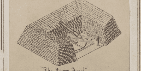
The foundation is a grillage, made of pine logs, crossed and bolted together. The center of gravity of the gun battery will be independent of the system upon which the gun rests, which is placed in the center of the platform. The timber work on which the gun rests in the center of the battery is independent of the parapet or its foundation. The foundation of the parapet receives a much greater load to the square foot than the gun-deck, and gun-deck’s weight elevates the entire structure on which the gun rests, not allowing the gun-deck to settle. i.e. If the battery should sink in the mud, the gun would be left standing on its own foundation, while the displacement would elevate the surface of the surrounding marsh, and tend, so far as it acted through or under the sheet piling which surrounds the gun platform, to elevate it. Thus, if the battery sank on its foundation, sand-bags could be piled upon it indefinitely, while the up heaved mud would form a glacis around it, and the gun would remain in one constant position.

The battery is in a rectangular shape formed by sheet piling. On this was laid a thick stratum of grass which was thoroughly tamped down; then followed two thicknesses of tarpaulin, on which was placed about 15 inches of well-rammed sand. Over this was laid three thicknesses of 3-inch pine plank. The interstices between the grillage logs are filled with sand, and around the logs are piled broken sandbags as a ramp, to give additional weight to keep it from rising unequally if the battery should sink.

A corduroy road (a road formed of logs and planks transversely placed in the mud), was built from the site of the battery, leading from its left side to the edge of the river. The gun and gun carriage, and the timber work forming the gun platform, were taken over this road from boats brought to the landing place, at the end, at high water.

During construction, all materials were carried by boats; many of the workers went to the job and returned this way. This was replaced with a plank walk built between Black Island and the Marsh Battery. After the night of the 12th of August most of the work-men were marched over the walk.. A platform was built on which a reserve covering party were stationed. Also, to secure the working parties against surprise, picket-boats were kept in the stream leading to James Island and Charleston Harbor, along with two naval boats with bow howitzers. Supplementing these precautions a boom of pine logs was put across the river to obstruct passage of boats that might attempt to come up from Charleston Harbor.

The building the Marsh Battery consumed the following labor and materials:
Thirteen thousand sandbags;
123 pieces, 15 to 18 inch diameter yellow pine timber 45 to 55 feet long,
5000 feet 1 inch boards ; 8 pallets 18 by 28 each;
9,156 feet 3 inch pine plank;
300 pounds 7-inch, and 300 pounds 4-inch spikes and nails ;
600 pounds round and square iron; 75 fathoms 3-inch rope.

These quantities do not include the material or labor employed in the bridges and plank walk across the marsh, and the boom, or the road and pier at the old engineer camp.

The gun to be fired from the swamp angel battery was an 8-inch Parrott Seacoast Rifle, invented by Captain Robert Parker Parrott, a graduate of West Point. He created the first Parrott rifle (and corresponding projectile) in 1860 and patented it in 1861. The Swamp Angel gun was manufactured the same year.

The gun was an iron tube 162 inches long. (Conflicting sources claim the gun to be 146 inches); weighing 16,500 lbs; with a bore of 8 inches. When it had a standard powder charge weighing 16 pounds to fire a 150 lb. Bolt (a solid projectile that included no explosive charge and had a cylindrical or spherical shape). It had an effective range of 8000 yards (just over 4½ miles at a constant elevation of 31º 30´.

The bombardment of the city of Charleston began from the Marsh Battery the night of August 21st. The Parrott rifle burst at the 36th round. No military results of great value were ever expected from this firing. which caused little damage and few casualties. Its primary purpose was to begin the bombardment of Charleston and a reign of terror on the civilian population.

Remains of the Swamp Angel Battery are still to be seen between Morris and Black Island. The Swamp Angel gun is now displayed in Cadwallader Park in Trenton, N.J.

McLeod Plantation Hosts Pete Marovich’s “Shadows of the Gullah Geechee”

2019-11-07T16:10:03-05:00

McLeod Plantation Hosts Pete Marovich’s “Shadows of the Gullah Geechee”

The Charleston County Park and Recreation Commission (CCPRC) is proud to host a one-day pop-up photography exhibit at McLeod Plantation Historic Site. On Sunday, Aug. 20, award winning photographer Pete Marovich will show selections from his exhibit entitled Shadows of the Gullah Geechee at the historic site on James Island.

Marovich’s photographs explore the lives and culture of the Gullah Geechee people in communities from Hog Hammock on Sapelo Island, Ga. to Mosquito Beach on Sol Legare Island, SC. His work captures everyday moments of work, play, worship and resilience to increasing pressures from real estate developments for the ever-expanding population growth in the Lowcountry.

Seventeen of Marovich’s stunning black and white images are part of the permanent collection of the Smithsonian’s National Museum of African American History and Culture. At McLeod Plantation Historic Site on Aug. 20, Marovich will be on hand to engage and discuss the 20 selected images of his work with visitors.

Admission to Shadows of the Gullah Geechee will be included with admission to McLeod Plantation Historic Site on Aug. 20. McLeod Plantation is open for regular visitation every Tuesday through Sunday from 9 a.m. to 4 p.m. Admission to McLeod Plantation is $15 for adults, $12 for ages 60 and up, or $6 for ages 3-12. Gold Pass holders (up to four guests per visit) and ages two and under are free of charge.
Located on James Island and owned and operated by CCPRC, McLeod Plantation Historic Site is a former sea island cotton plantation that has borne witness to some of the most significant periods of Charleston history. Today McLeod Plantation is an important 37-acre Gullah-Geechee heritage site carefully preserved in recognition of its cultural and historical significance. The site’s buildings include homes that make up Transition Row, where enslaved families and their free descendants lived during the 19th and 20th centuries.


For more information, visit CharlestonCountyParks.com/McLeod or call 843-762-9514. McLeod Plantation Historic Site is located at 325 Country Club Drive on James Island

Daddy Meets Gershwin on Folly Beach in 1934

2017-07-21T11:21:27-05:00

Daddy Meets Gershwin on Folly Beach in 1934

Blog By Nancy Crosland Taylor

It was 1934 – summertime in Charleston. My father was there; he was a first-year student at the Medical University, just starting out on his lifetime dream of being a doctor, as so many men in his family had been before him. The city must have been another world for him – he came from the small town of Bennettsville, which had none of the sophistications of Charleston.

One afternoon, he and a classmate were in Henry’s, a venerable old bar across the street from the Market that provided a cool, dim refuge from the hubbub outside. They nursed their drinks…stretched them out…since they didn’t have much money to spend on such frivolities. After a while, a man sitting in the shadows at the far end bought them each another drink and asked if he could join them. Of course, said the young men.
I don’t know what they talked about; Daddy never told me that. Probably women.

Eventually, the man rose; he told the other two that he had best get on his way. Then he invited them to visit him at his rented oceanfront cottage at Folly Beach the next afternoon, and directions were given.

Daddy and his friend had no idea who George Gershwin was, but they did drive out to Folly. When they parked and exited the car, they heard piano music. A voice from the house told them to come in.

They climbed the steps and entered through the screened door to find Gershwin at the piano, just playing with the notes. He was composing the music for “Summertime”.


How I wish now that I had asked questions and fleshed out this skeleton of a story. What a grand experience had befallen my dear daddy, without him even knowing just how grand. He related this story many times during my childhood. It’s been only in recent years that I’ve become so interested in filling in my blanks about his life.
So, I’m coming to Folly next year to visit the place where my father spent an afternoon with George Gershwin. My first time there. My children have told me that they want to go with me, and I’m thrilled! It just couldn’t be any better!

Go to Top